Arboriq
SaaS Platform

Project Type
Concept Study
Industry
Environment
Services
SaaS Product Design & Development

Overview

Arboriq is a product design concept for tree survey records. Survey teams need each observation and photograph tied to the correct tree identifier and visit. The scope connects four activities: tree map, survey record, visit planning, photo comparison. Each has a dedicated screen, with a street-tree map with photographic record drawer establishing the visual direction. The work includes interface composition, proposed feature architecture and industry-specific showcase imagery.

Arboriq SaaS Platform hero

Four original tree survey records interface concepts. Records, technical values and depicted workflows are illustrative.

Challenge

Survey teams need each observation and photograph tied to the correct tree identifier and visit. A useful workspace must preserve the connection between the original reference, the selected record and the discussion around a change. Showing more information alone would not resolve that handoff.

  • Keep tree identifiers and location references connected to the selected work.
  • Make observation fields visible at the point where decisions are reviewed.
  • Retain survey itinerary and record revisions through the handoff.

Solution

The design starts with a street-tree map with photographic record drawer. Locate fictional tree records on a neighborhood map with selected-tree details. The remaining views separate exploration, coordination and review into layouts suited to their content. A forest, bark brown and pale mint palette gives the product its own visual identity, while selected-record panels keep details close to the working surface.

  • Locate fictional tree records on a neighborhood map with selected-tree details.
  • Inspect a tree photograph beside descriptive observations and visit notes.
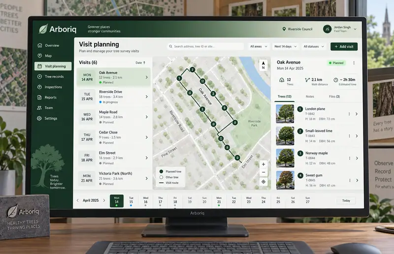
  • Organize planned survey visits on a street-based itinerary and calendar.
  • Compare dated tree photographs with contextual annotation notes.

Results

  • 4

    Specialized
    concept views

  • 12

    Proposed
    feature areas

Let’s CraftingVisual ImpactStart a Project

We Are Available For New Project

Arboriq
SaaS Platform

Project Type
Concept Study
Industry
Environment
Services
SaaS Product Design & Development

Overview

Arboriq is a product design concept for tree survey records. Survey teams need each observation and photograph tied to the correct tree identifier and visit. The scope connects four activities: tree map, survey record, visit planning, photo comparison. Each has a dedicated screen, with a street-tree map with photographic record drawer establishing the visual direction. The work includes interface composition, proposed feature architecture and industry-specific showcase imagery.
Arboriq SaaS Platform — hero

Four original tree survey records interface concepts. Records, technical values and depicted workflows are illustrative.

Challenge

Survey teams need each observation and photograph tied to the correct tree identifier and visit. A useful workspace must preserve the connection between the original reference, the selected record and the discussion around a change. Showing more information alone would not resolve that handoff.

  • Keep tree identifiers and location references connected to the selected work.
  • Make observation fields visible at the point where decisions are reviewed.
  • Retain survey itinerary and record revisions through the handoff.

Solution

The design starts with a street-tree map with photographic record drawer. Locate fictional tree records on a neighborhood map with selected-tree details. The remaining views separate exploration, coordination and review into layouts suited to their content. A forest, bark brown and pale mint palette gives the product its own visual identity, while selected-record panels keep details close to the working surface.

  • Locate fictional tree records on a neighborhood map with selected-tree details.
  • Inspect a tree photograph beside descriptive observations and visit notes.
  • Organize planned survey visits on a street-based itinerary and calendar.
  • Compare dated tree photographs with contextual annotation notes.

Results

  • 4

    Specialized concept views

  • 12

    Proposed feature areas

Let’s Crafting

Visual Impact

Start a Project